Our last post informed you about the NSW governments notion of embracing Social licence and how important they say it is to have community support and buy in for development in an area. We are yet to receive a response to the SSAG’s letter to Rob Stokes, NSW Minister for Planning and Public Spaces questioning why the Springdale solar development was approved with absolutely no social licence.
The Sutton Solar Action Group (SSAG) has continued to voice our concerns about the Independent Planning Commission’s (IPC) decision to approve the Springdale solar development and asked our local member Mrs Wendy Tuckerman, MP, Member for Goulburn to visit the area and see for herself what the impacts will be, especially visually.
As we all know Renew Estate and RES downplayed the visual impacts of the project on surrounding properties and completely ignored the impact on residents who live to the east of the site. On page 21 of the Department of Planning, Industry and Environment’s (DPIE) Assessment Report it states, ‘RES clarified that although the VIA did not provide a detailed assessment of all residences within 2 km of the site it considered that the residences not included would not have views of the project due to intervening topography.’ Its clear that whatever a developer says is taken as the truth, with no questions asked by the DPIE. We also note that despite three separate versions of visual assessments there was no consensus on visual impacts on individual residences.
Below is DPIE’s map showing the 35 residences within 2km of the site. We selected three residences around the site for her visit, R2, R5 and R13 to show the views from different locations and angles.

Source: DPIE Springdale Solar Farm (SSD 8703) | Assessment Report page 21
To say Mrs Tuckerman was shocked at what she saw before her is an understatement. The sheer size of the solar development and where it sits at the bottom of a valley without the ability to be effectively screened was a total eye opener for Mrs Tuckerman. She also commented about how it is impossible to perceive these developments unless you actually visit these locations, and that a piece of paper with a map on it does not reflect the actualities of what is proposed.
We also drove Mrs Tuckerman along the proposed heavy vehicle traffic route along East Tallagandra Lane and through the village. Mrs Tuckerman was amazed that this route was chosen and raised concerns about its suitability, especially the causeway that crosses McLaughlins Creek.
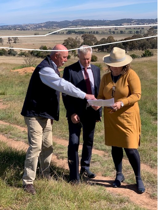
Sutton District and Community Association Inc. (SDCAI) President Mark Burgess (on the left) showing Mrs Tuckerman (on right) where this residence (R13) is located on figure 11. shown above and the extent of his view, i.e. the area inside the white line.
Much of the vegetation within the white lines will be removed to make way for solar arrays and shipping containers.
In the middle is the impacted resident John Brennan. John’s family place a high value on this view, representing as it does an essential and visible part of the biodiversity corridor that he has helped encourage by plantings of native trees and reductions in stocking rates on his property, which directly adjoins the proposed property.
DPIE claim they will not see the development because of topography and the proposed vegetation screening. FALSE
Rather than take the time to consider the objections raised by residents, DPIE blindly accepted RES’s claims.
No matter how much vegetation they plant, this development cannot be hidden because it is in the bottom of a valley.
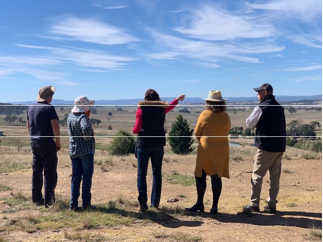
From left to right: residents of R5 and SSAG members, Dianne Burgess, Wendy Tuckerman and SDCAI President Mark Burgess
SSAG member Dianne Burgess (middle) showing Mrs Tuckerman (on her right) the extent of the Springdale development from another angle, this is what the residents of R5 will see. The entire development site can be seen from here, i.e. the area within the white lines. There is no possibility of this being screened.
Again, much of the vegetation within the white lines will be removed to make way for solar arrays and shipping containers.
The DPIE considers these residents will only be moderately impacted and that topography and proposed vegetation screening will hide the development. FALSE
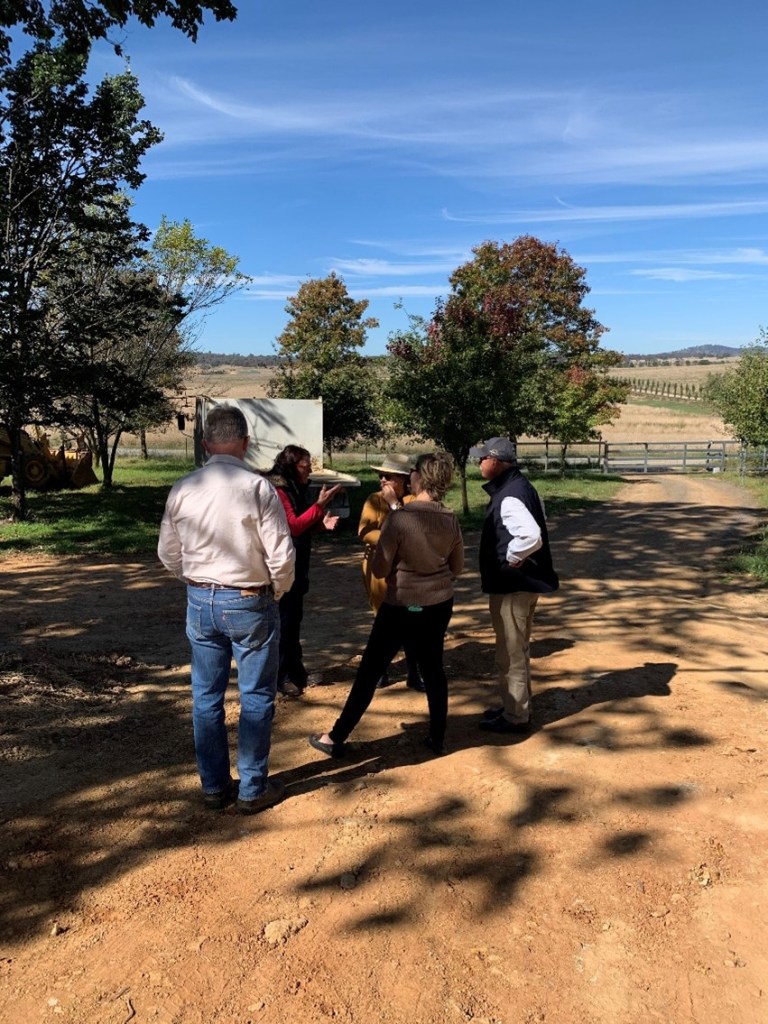
Mrs Tuckerman meeting with two of the landholders of Tintinhull Road, which divides the solar development into east and west sections.
R2 resident Jacqui Hassall’s (fourth from the left) property adjoins the development site and lives at the end of Tintinhull Road. Her family will have to pass through this development every day for 35 years should this development be built.
The landscape plan, which is still up for debate, with everyone except the impacted residents, has no provision to screen two thirds of Tintinhull Road and will also have at least a 2m high security fence around the solar array fields and run along either side of the road. It will be like driving through a minimum-security prison.
RES, the DPIE and the IPC believe this is an acceptable outcome. The DPIE even went as far as changing the visual impact assessment rating from high down to moderate.
Mark O’Shea (first on the left) owns 600 acres on Tintinhull Road. His property also adjoins the property and at one time thought about building on the site to take in the extensive views over the valley. All that would be seen now would be vast acres of solar arrays and shipping containers.
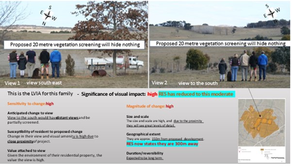
This is the Hassall’s family’s view over both sides of the development site. The white stripes on the images are the proposed 20m wide vegetation screenings. RES also changed their proximity to the development from 150m to 300m. A purely aribitrary decision by RES.
In the image on the left (above) the hill is at least 10-15m higher, so to screen out the infrastructure the vegetation will need to grow to at least 20m in height to provide a successful screen.
In the image on the right (above) the hills are at least 30-40m higher than where the family are standing. To provide an adequate vegetation screen the vegetation will need to grow to at least 40 or 50m.
DPIE’s approval conditions state that a mature vegetation barrier is to be installed and maintained. What is determined as mature vegetation and how will the developer guarantee maintaining such a barrier? How is it even possible to audit such a condition, what is the benchmark for this sort of thing, is there one?

The image above is from RES’s submission to the IPC for the Springdale solar assessment. This is their vision and how they see renewable energy developments being built, the DPIE and the IPC obviously support this view. There is something fundamentally wrong if this is the vision that the planning authorities have for regional New South Wales.
Who would want to have to look at this for the next 35 years or more? Noting that the area in the picture is flat, and vegetation may be able to screen the infrastructure, but as we demonstrated to Mrs Tuckerman, put this image in the bottom of a valley and it will be seen by all.
The following has been taken from the SSAG’s submission to the IPC following the Springdale ‘public meeting’. In it we referenced two recent decisions about visual impacts that we believe should be used as standard assessment measures for DPIE and IPC assessments.
Effectiveness of proposed visual impact mitigation and other ‘experts’ comments
First, we refer to the DPIE’s own independent expert O’Hanlon who conducted an Independent Review of the Jupiter Wind Farm where vegetation screening was also proposed as a mitigation to hide the wind turbines.
O’Hanlon stated that the proposed mitigations were highly optimistic and that if successful it may take many decades or possibly much longer to achieve results. Vegetation screening should only be used judiciously and where the likelihood of success is high. And that where slopes exist the probability of success is considerably less due to the variability in soils, water run-off and maintenance of plantings.
The review of the Jupiter site was based on existing conditions without any modification or mitigation. It noted that the area proposed for the wind farm development was predominately high-quality pastoral lands or ‘lifestyle’ properties with residences built to take advantage of the extensive views. It also stated that pastoral lands can have significant scenic quality and are extremely sensitive to changes in the landscape character.
O’Hanlon concluded that should the proposed development be approved that it would change the landscape from pastoral to industrial and that the proposed mitigation was unlikely to achieve a sufficient level of mitigation to overcome the level of objections regarding visual impact on residents.
Secondly, we refer to the Rocky Hill Mine Decision [2019] NSWLEC7.
Mr Moir who appeared for the NSW Minister for Planning made these comments.
Mr Moir explained that the assessment of the visual quality of the landscape has regard to the following parameters (s 97):
- visual quality increases as:
- relative relief and topographic ruggedness increases.
- vegetation pattern variations increase.
- due to the presence of natural and/or agricultural landscapes
- the presence of water forms in the landscape
- with increases in land use compatibility
Mr Moir also stated that residences both within a township or are rural residences have a high visual sensitivity within 0km to 2km. He also said that visual effect should be taken at a point in time without considering mitigation.
Both Moir and O’Hanlon’s assessments consider rural residences within 2km will be highly impacted visually and both agree assessments should be undertaken without the proposed mitigation, which is reasonable considering the LVIA’s are purely theoretical and aspirational, not actual results.
The same can be said for land uses and ‘vicinity’ which also deals with visual impact.
Mr Darroch who also appeared for the Minister for Planning in the Rocky Hill Mine case, stated that ‘vicinity’ and ‘land use’ are also relevant considerations. … ‘Determining the uses of land in the vicinity involves consideration of not only the proximity or nearness in space of the uses of land… but also visual considerations and “demographic and geographic features of the area”…
Mr Darroch also stated that the residents and visitors to an area are never fixed in any one spot. They do not only experience the impacts of the proposed site statically from their living room window or front yard. They will be impacted as they move around their entire property which is characterised as the “vicinity”. He noted that many objectors referred to their loss of enjoyment of their rural properties by being able to see the development from different viewpoints.
Large scale solar energy generating facilities assessment does not consider current, future, or historical land uses or social impact assessments as they do for mining. There was no consultation with any of the landowners to gather information for the Land Use Conflict Risk Assessment (LUCRA), it was nothing more than a last-minute tick and flick exercise.
The following comment is taken from page 12 of the LUCRA and shows how much consideration is given to impacted residents, ‘the solar farm would remain visible for some receptors despite screening vegetation proposed around the perimeter. This potential conflict is however expected to ease over time for most receptors as screening vegetation matures and people become accustomed to the development. How impertinent can they be! In other words, ‘they will just have to live with it!
The statements made by the Minister’s representatives Mr Moir and Mr Darroch were accepted as correct by the Judge in the Rocky Hill case in the NSW Land and Environment Court (LEC) and the comments made by O’Hanlon were sufficient enough for the DPIE to recommend that the Jupiter Wind Farm not be approved. The developer subsequently withdrew the development application.
Yet, in the case of the Springdale solar development, the DPIE has ignored the Minister’s own experts like Moir who states that 0km – 2km constitutes high visual sensitivity; and Darroch, who considers past, present, and future land uses in the vicinity as important considerations; and even the DPIE’s own independent assessor who considers pastoral lands as being highly sensitive to change, and that the addition of wind turbines would change the site to industrial land.
Why did the DPIE use a different standard to assess the Springdale development? How can there be different standards for different types of developments?
Mrs Tuckerman has taken onboard our concerns and is endeavouring to assist the community by asking Minister Stokes to visit the site and see for himself first-hand what the impacts will be and how flawed the decision to approve the Springdale solar development is.

You must be logged in to post a comment.